
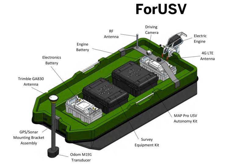
ForUSV
An Unmanned Surface Vessel for shallow water survey operations. Piloted via autonomous waypoint control or remotely-operated over various data links from a Ground Control Station.
Call For Quote: 1.888.553.6783
Real-time live video, navigational and sonar data is fed from the vessel direct to survey operators at the Ground Control Station, whether on land or an offshore mother ship, providing them with immediate actionable intelligence. All data is automatically recorded for the purposes of After-Action Reports (AAR).
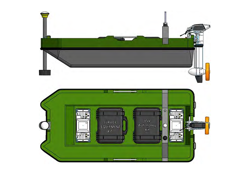
The lightweight and modular design allows for easy assembly, disassembly and transportation. The entire vessel can fit into the back of a standard pickup truck.
Designed for survey speeds of 3-4 knots, with a maximum engine depth below waterline of 33cm (we also have deep water boats as well) and grounding protection, the SWS-3 USV can be used in locations inaccessible to most survey vessels safely and economically.
HOW IT WORKS
Integration of our Proprietary Software
The proprietary software is the marine autopilot at the heart of the software’s USV Autonomy Kit. It is integrated into the ForUSV, allowing the operator full control over the propulsion, steering, and payload systems of the USV.
A wide variety of additional customer-specific payloads can be quickly integrated into the SWS-3 to meet everchanging mission requirements. We can customize any fleet to our proprietary software
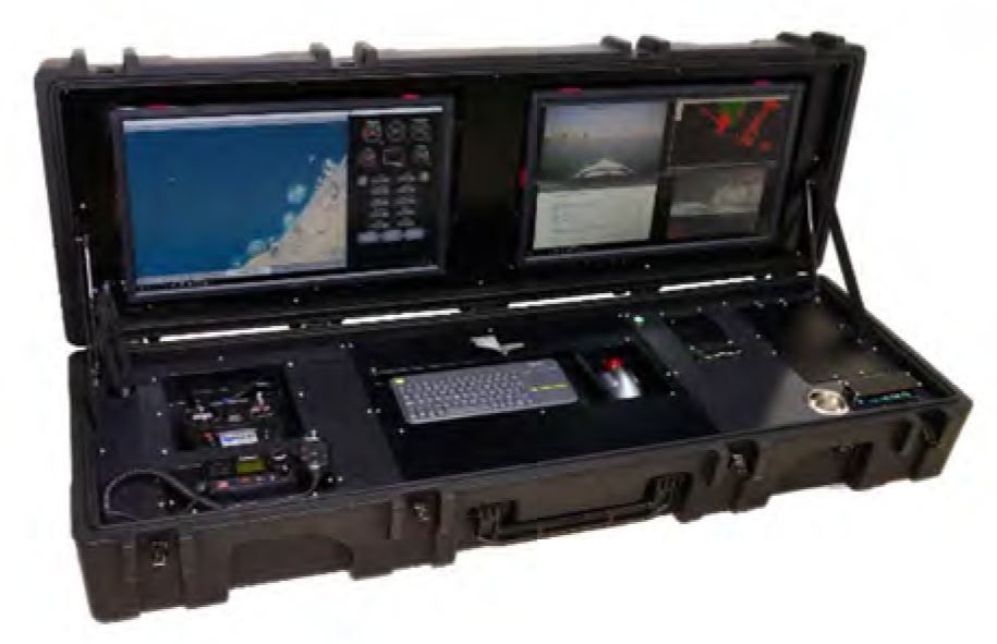
Mobile Ground Control Station
The C2 Pro is a mobile ground control station (GCS). The multi-functional GCS is easily customized, mobilized and operated, thereby satisfying the requirements of a wide spectrum of remotely operated missions. Operators can plan and upload routes to the USV; access its navigational charts, engine data, anddiagnostic information; and control the onboard payload system of the vessel. Alternatively, ForTechnologies offers the C2-20, a fully customizable GCS designed to control a fleet of USVs from a 20”-container.
FEATURES
Hydrographic Applications
- Shallow Water Bathymetry
- Multibeam Survey
- Cutter Dredger Monitoring
- Dredge Port Monitoring
- Cable Lay Monitoring
- Port Entrance Monitoring
- Operations Monitoring
Hydrographic Applications
- Plan and upload routes for autonomous navigation through the MAP Planner software.
- Access navigational charts, engine data, and sensory information from the USV.
- Control onboard payload specific to the current mission.
TECH SPECS
| Physical Specifications | |
| Dimensions | 262cm(L) x 122cm(W) x 51cm(H) (Vessel Only) |
| 291cm(L) x 122cm(W) x 125cm(H) (With Payload) | |
| Vessel Dry Weight | 62 kg (Vessel and Engine) |
| Vessel Payload Weight | 114 kg |
| Max Payload Weight | 249 kg |
| Max. Speed | 5 knots |
| Electrical Specifications | |
| Electronics Battery | 12 V, 180 Ah |
| Power Consumption | 320 W |
| Communications Specifications | |
| Communications System | 4G-LTE, RF point-to-point |
| Communications Range | Unlimited¹, 4km LOS |
| Engine Specifications | |
| Engine | 2000 W (5 hp) electric outboard |
| Steering | Mechanical |
| Engine Battery | 24 V, 3507 Wh |
¹ Range operated over 4G-LTE is unlimited where coverage is available.
Call For Quote: 1.888.553.6783
Want To Learn More?
Ask us about our other protection technology solutions…